Exploring the Pacific Northwest by RV
Helpful Tips on Traveling the Pacific Coast from California's Redwoods Through Washington's Olympic Peninsula
Article Date: August, 2008
Article and Photography by Mark Quasius

The Washington Coast
The Washington Coastline is different than the Oregon coastline. While the Oregon coastline is noted for its wide beaches and
sea mounts, the Washington coastline changes rapidly as you head north. The road generally does not follow right along the coastline as in Oregon.
The area is heavily used for logging so vast forests of Douglas Fir cover the area. The Olympic Mountains act as a barrier in the northern portion
and trap the moisture coming off the Pacific Ocean. This climate is excellent for growing dense forests full of large trees. In fact there is a
rain forest in Olympic National Park just for that reason. Because the Olympic Mountains form the center of the Olympic Peninsula, there are no
roads through the interior. Therefore most coastal trips will head east at the northern end of the peninsula and head to Port Angeles and points
farther east.
Kalaloch

Kalaloch Sunset
Immediately after crossing the bridge at Astoria you'll be given a choice. US-101 heads left to Seaview before doubling back
around the Wallapa National Wildlife Refuge to continue heading north. That's the long way around. Instead, take the 401 shortcut to Naselle and
then head north, saving some time and mileage. Farther up you will reach Aberdeen and Hoquiam, which are located along Gray's Harbor. As you continue
north you'll pass by many forests of Douglas Fir. This area is used heavily for logging and forestry.

World's Largest Spruce Tree
Another 42 miles will bring you to Quinault, Lake Quinault is part of Olympic National Park. There is a campground there that
is located next to the world's largest spruce tree. This tree is 191' tall, has a 96' spread, and the trunk is 58' around. It's about 1,000 years old.
The campground is part of the
Lake Quinault Lodge and is within the park. While it's a nice campground, we opted for one closer to the coast.

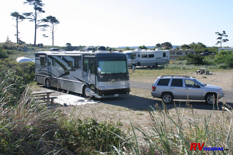
South Beach Campground
Immediately south of Queets is Kalaloch. There is a nice little lodge there but camping is limited to tents and the very smallest
RVs. A few miles south of Kalaloch is a US Forest Service campground called South Beach. It's nothing more than a series of terraced overlooks that look
out over the Pacific Ocean. You parallel park so you have an excellent view out the side of your coach. Fire pits and picnic tables are provided and a
waterless rest room is provided. It's boondocking but the view is worth it.

South Beach
The beach extends for many miles. You can take strolls along the beach with the ocean on one side and forested bluffs on the
other side. Chances are you'll see bald eagles perched on snags. Many small streams run down from the bluffs and beachcombing at low tide can be
rewarding. High tide is another situation however. The stacks of logs that are piled up between the beach and the bluffs show you just how far the
surf can come crashing in.

Spruce Burls
If you take the toad north from South Beach along US-101 you'll find four beach access roads that are spread out over the next
few miles. These roads will access parking areas with trails that will take you down to the beach at key areas of interest. As these trails pass
through the dense forests you'll see a number of spruce and fir trees with large burls on them. The moist environment encourages this growth and
rivals the redwood burls seen in California's dense redwood forests.

Ruby Beach
One such beach is Ruby Beach. The northernmost of this series, Ruby Beach has a stream that drains into the ocean, forested
approaches, and seamounts. The bleached driftwood logs are typical of this area. If a tree topples and is washed out to sea, the waves will return
it to the shore. The sun and weather contribute to a bleached appearance after time.

Seamounts at Ruby Beach
The seamounts at Ruby Beach guard tidal pools where marine life can be seen at periods of low tide. The largest one has a
small forest growing on its top where shore bird colonies exist.
Hoh Rain Forest

Hoh Rain Forest
Heading north up the coast from Kalaloch, you'll meet up with the Hoh River. Following this road into Olympic National Park
will take you to the Hoh Rain Forest portion of the park. Olympic National Park is a large area where there are no interior roads. The Olympic
Mountains and their wildlife are basically unreachable for the most part unless you are a hardy adventurer. There are three key areas though where
the park service has established visitor centers for the average tourist. One of these is the
Hoh Rain Forest.
The Hoh Rain Forest unit of Olympic National Park receives between 140 to 170 inches of rain every year. Naturally, things
tend to grow when that kind of moisture is present. Unlike a Tropical Rain Forest, which is found in hot climates, this is a Temperate Rain Forest
because it doesn't get that hot on the Olympic Peninsula. Most visitors didn't even know that such a place existed let alone finding it in Washington
so this can be a very interesting visit.

Tall Sentinels
We took our motorhome down the road to the visitor center for the Hoh Rain Forest. It was tight parking and a long winding
road through the forest but it was worth it. After parking we found two trail loops. The long loop would have taken too much time but the shorter
Hall of Mosses trail was just right. So we ate lunch in the RV and then took off for a short hike.

Collonades
The Hall of Mosses Trail is a short 0.8 mile loop through old growth temperate forest with only a 100' gain in elevation. It
winds its way through moss covered trees and colonnades. Colonnades are trees that have fallen. The moist conditions allow them to rot and hold moisture.
Seeds from neighboring trees fall on them and the new trees actually take root in trunk of the fallen tree and begin to grow without ever touching the
ground.

Hall of the Mosses Trail
The trail passes through many unique areas. Fallen trees line the path and you will find wildlife in this area. Woodpeckers,
banana slugs, and deer and elk frequent the area.

Arched Tree
Heading back to the visitor center you'll notice many different shapes of trees. Various arches and other shapes are formed as
these trees twist and turn to change with their environment.
Moving On

Straits of San Juan
US-101 continues north after exiting the Hoh Rain Forest. It passes through Forks along the way. There is an RV park in Forks
called Forks 101 RV Park that is handy to the Hoh Rain forest as well as Rialto Beach
and Cape Flattery but it appeared a bit on the tight side and they have a very strict policy regarding dogs so we passed on it. At this point US-101
ends its northerly trek and takes a turn to the east along the north coast of the Olympic Peninsula. If you want to drive out to Cape Flattery you can
do it at this point. There is a campground at Neah Bay on the Makah Reservation but I am not familiar with that area (until next trip ) so can't comment
on them. Check the various campground reviews before committing to stay there. Otherwise you can just follow US-101 to the east towards Port Angeles and
Port Townsend.
Return to Home Page
If you enjoyed this article be sure to recommend RVtechMag.com to your friends, like us on Facebook or Twitter
or subscribe to our RSS feed.


|